 Pojarevo
  Nanovitsa
  Dokovți
  Ognyanovo
  Podles
  Dragomani
  Dolna Ribnitsa
  Selishte
  Rashovite
Regional Historical Museum on the map, Ruse, Bulgaria
Photo

Where is located Regional Historical Museum
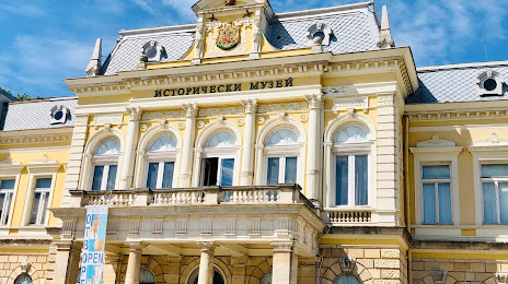
Regional Historical Museum — local attraction, which is located at pl. "Kniaz Aleksander Batenberg" 3, 7000 Ruse Center, Ruse, Bulgaria and belongs to the category — museum. Average visitor rating for this place — 4.7 (according to 1086 ratings, information from open sources and relevant for 2022).
Exact location — Regional Historical Museum, marked on the map with a red marker.
You can get directions to Regional Historical Museum on the map from your location.
What else is interesting in Ruse? You can see all the sights if you go to the city page.
Coordinates
Regional Historical Museum, Bulgaria coordinates in decimal format: latitude — 43.84403125840435, longitude — 25.947625425053435. When converted to degrees, minutes, seconds Regional Historical Museum has the following coordinates: 43°50′38.51 north latitude and 25°56′51.45 east longitude.
Nearby cities
The largest cities that are located nearby:
- Bucharest
(Romania) — 66 km
- Pleven — 119 km
- Ploiești
(Romania) — 121 km
- Pitești
(Romania) — 142 km
- Stara Zagora — 158 km
- Buzău
(Romania) — 161 km
- Craiova
(Romania) — 179 km
- Râmnicu Vâlcea
(Romania) — 187 km
- Brașov
(Romania) — 204 km
- Plovdiv — 213 km
- Constanța
(Romania) — 215 km
- Brăila
(Romania) — 222 km
- Focșani
(Romania) — 226 km
- Galați
(Romania) — 238 km
- Edirne
(Turkey) — 244 km
- Sibiu
(Romania) — 258 km
- Drobeta-Turnu Severin
(Romania) — 274 km
- Bacău
(Romania) — 312 km
- Niš
(Serbia) — 332 km
Distance to the capital
Distance to the capital (Sofia) is about — 248 km.